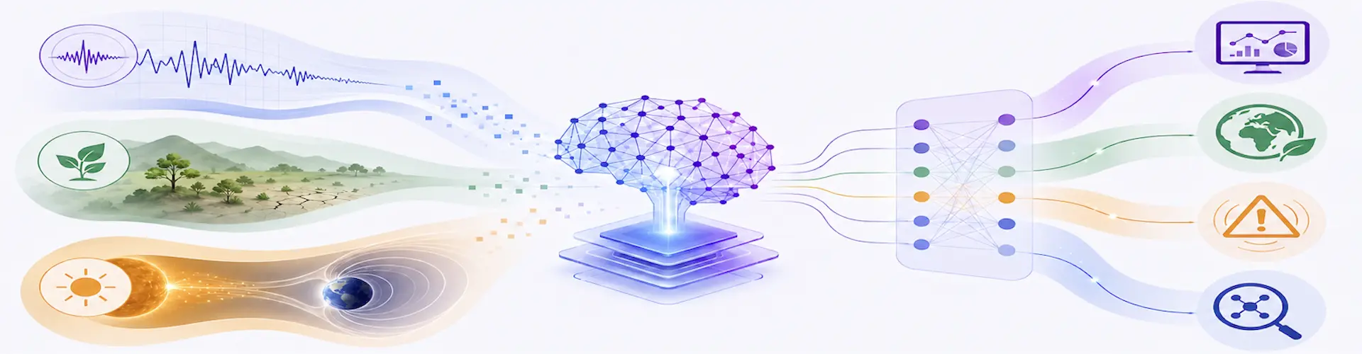

ATLAS Machine Learning Applications
We apply advanced machine learning techniques to particle physics analyses and to interdisciplinary problems such as seismic monitoring, environmental studies, and space weather prediction.
TERREMOTOS
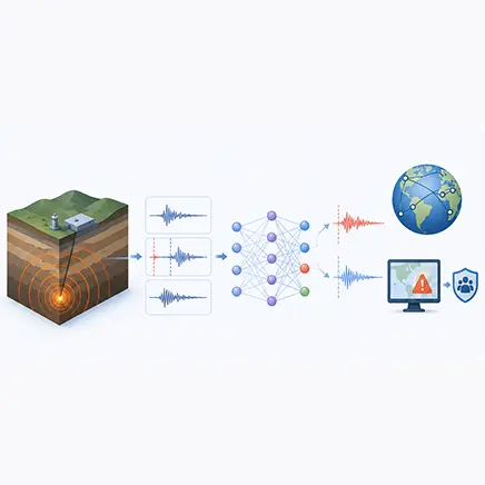
We work to improve seismic data analysis using advanced deep learning techniques. Our objective is to enhance the automatic detection of seismic phases, particularly P and S waves, by training neural networks to identify these signals in real earthquake recordings. To ensure robust performance, we have developed and validated dedicated datasets designed to evaluate deep learning models under realistic seismic conditions.
By leveraging these approaches, we aim to increase the speed and accuracy of phase picking, a critical step for earthquake location, early warning systems, and rapid emergency response. Our methods provide a scalable and efficient alternative to traditional algorithms, capable of processing the large data volumes generated by modern seismic networks.
Through this work, we contribute to more reliable seismic monitoring and to the development of advanced tools that can reduce the societal impact of earthquakes.
DESERTIFICACIÓN
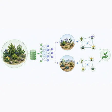
Our group has contributed to a study demonstrating how Artificial Intelligence, particularly transfer learning, can improve the understanding of plant species coexistence in diverse ecosystems. We applied deep learning models to predict species interactions in communities where ecological data are scarce.
A model trained on a well characterized plant community in Petrer, Spain, was successfully transferred to predict interactions in two additional ecosystems: La Unión in Spain and San Juan Raya in Mexico. By combining limited local datasets with knowledge learned from a larger reference dataset, we significantly improved the accuracy and robustness of ecological predictions.
This approach provides a powerful framework for studying biodiversity in data limited regions. It offers practical applications for conservation planning, ecosystem restoration, and the management of areas affected by degradation or desertification. Our work highlights the potential of transfer learning to advance ecological modeling and support evidence based strategies for biodiversity conservation.
SOLAR WEATHER
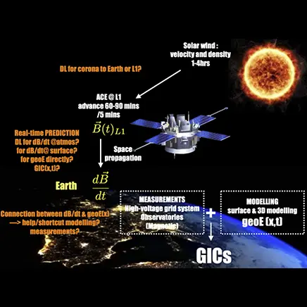
This project aims to develop an early warning system to evaluate the impact of severe solar storms on Spanish critical infrastructures such as the power transmission grid, railways, and oil and gas pipelines. Specifically, we are developing a predictive model to assess the ground-level impact of future solar storms. The model will consist of two distinct stages.
First, we will use real-time data from NASA’s Advanced Composition Explorer (ACE) solar wind space probe, located at the L1 Lagrange point, together with past conditions to train a deep learning model that predicts variations of the magnetic field at the Earth’s surface at different locations across the Iberian Peninsula. Second, these local predictions of the time variation of the magnetic field will be used as input to a physical model, developed by the University of Barcelona, describing the three-dimensional geoelectrical structure of the Earth in order to compute the geoelectrical fields that drive geomagnetically induced currents (GIC).
We will use data from the geomagnetic observatories of Ebro, San Pablo de los Montes, and San Fernando in Spain, as well as Coimbra in Portugal, to optimize the model for the Iberian Peninsula.
This project is carried out through a collaboration among three institutes: Observatori de l’Ebre (CSIC–Universitat Ramon Llull), Universitat de Barcelona, and IFIC (CSIC–Universitat de València), contributing expertise in space weather and GIC modeling, geoelectrical modeling, and deep learning techniques, respectively.